Hi! Since I have been slacking at home resting, thought it is also nice to post something I've done in the past but has no chance to share. During end of 2005, my friends and I visited Sungei Punggol for a project for my Biophysical Environment module. If there is any part that you think has already changed since its a difference of about less than 2 years, do update me too, I'm interested to find out.
-------------
Location: River banks at western side of Sungei Punggol
Above: Circled is the area of field study done
(Map from http://www.streetdirectory.com.sg)
Date of field work: 15 October 2005
Objective:
1. Appreciate the ecological features and the importance of mangrove in Sungei Punggol.
2. To observe and study the impacts and implications of urbanization and land development that causes changes on the mangrove at Sungei Punggol.
Introduction and History:
Mangroves are dominated by coastal plants that are able to adapt to estuarine or saline environment. These species develop best inside tidal river mouths and along sheltered shores. One of their characteristic adaptations is the ability for its thick and waxy leaves to secret salt using special glands and also the ability to perform ultra-filtration to resist saline conditions. Also, mangrove plants have features like specialised root system for stability and anchorage and pneumatophores or breathing roots to absorb oxygen in an anoxic condition. Mangrove soil is mainly made up of sandy soil, soft humus-rich mud and stiff clay which are slightly acidic and black and this mixture is constantly waterlogged and not well oxygenated. However, this condition does allows rich organic matter to decompose slowly. The propagules, mainly dispersed by currents, are developed into a shape that allows firm and upright anchorage and they will take root and grow quickly due to vivipary, a condition whereby the embryo grows first to break through the seed coat out of the fruit wall while still attached to parent plant.
Above: Breathing roots of the Avicennia alba can be seen beneath its vegetation.
There are many uses of mangroves which include wood for fuel or building and sustaining of young shrimps or fishes by providing shelter as a nursery or spawning area. Kelongs and fisheries suffer when these natural breeding grounds are removed which led to decrease in the yield of fishes and shrimps. More uses include coastal stabilization or shoreline protection that will minimize impacts from the sea, in turn cutting down erosion. Mangroves also act as a pollution filter as the pollutants get locked and trapped in the mangrove soil.
Prior to the founding of Singapore in 1819, mangroves were very extensively available along the coast, practically covering the whole of the northern and western island. However, today, after to a large degree of land exploitation, only fragments of Singapore’s original mangroves survive over at Sungei Buloh, Changi Creek, Khatib Bongsu, Sungei Punggol, Sungei Serangoon, Pandan and some other offshore islands like Pulau Ubin and Tekong. Currently, physical disturbance like reclamation and restoration in estuarine and coastal waters may seriously affect the marine environment. This will in turn lead to increased water turbidity, enhanced sediment deposition and other disturbances.
Sungei Punggol or Punggol estuary, lies between latitude 1° 22'54"N & 1° 24'42"N latitudes and longitude139° 52'24"E & 139° 54'12"E is approximately 2.5 kilometers long. It is a mangrove fringed estuary at the northeast of Singapore and it opens into the East Johor Strait. Impressively, the mangrove ecosystem at Sungei Punggol was recognized as one of the only 4 wetlands left in Singapore frequented by migratory birds. The Great Egret (Egretta alba) was sighted flying around the area during the field session at Sungei Punggol.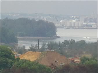
Above: A photo showing the river mouth of Sungei Punggol with construction nearby
Since 1966, changes have taken place to its surrounding. It was previously a pig farming area but was phased out to reduce pollution in 1984. It was until the initiation of Punggol 21 Housing Project by the Urban Redevelopment Authority (URA) then impacts like dredging, reclamation, construction activities, dumping and mangrove deforestation occurred around 2001. The reclamation of the river mouth area affected the ecology due to environmental pollution. Construction of river bank embankments, shoreline, LRT and bridges over the river have also caused to the deforestation of the original mangroves. However, during 2002, recolonisation of the mangroves on the grassy banks was observed, because with adequate and suitable conditions and grounds, there is a possibility that mangroves can regenerate and colonize the river banks again.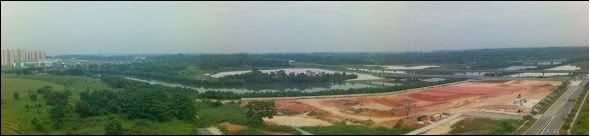
Above: A paranormal top view of Sungei Punggol stretching from Punggol to Hougang
At present, the stretch of the river banks of Sungei Punggol is mostly covered by mangrove but the size is relatively thin with the mangrove forming only near the river bank compared to those at Sungei Buloh with different zonations like the back mangrove, main forest and the sand banks. This is probably due to the recolonisation state where many new mangrove species are still growing as seen on the photo below and also due to limited land space from the construction in the vicinity.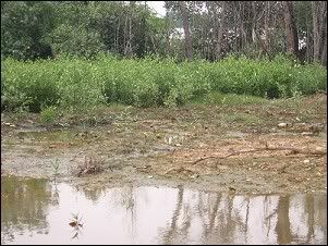
Above: Young mangroves are found growing near the banks of Sungei Punggol.
The mangrove plants that dominated the area are Api-api putih (Avicennia alba) and Sea Hibiscus (Hibiscus tiliaceus). Few Nipah palms (Nypa fruticans) were sighted along the mangrove. The presence of burrow heaps or mud lobster holes, is actually an indication of a healthy mangrove ecosystem. This is because these mud lobsters (Thalassina anomala) play a significant role by providing aeration in the highly compacted, waterlogged and anoxic soil condition and these provide oxygen to the deeper layers. There were quite a number of Giant Mudskipper (Periophthalmus schlosseri) found inhabiting in the area and they are the most conspicuous fish in our mangroves mainly because they spend most of their time out of water and they can glide in an agile manner.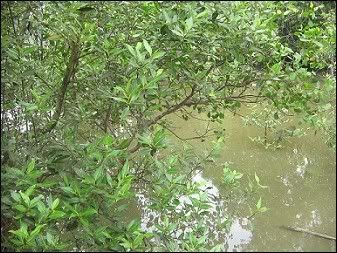
Above: Api-api putih (Avicennia alba)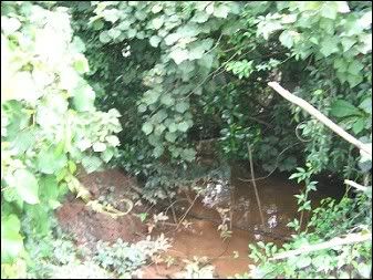
Above: Showing the leaves of Sea Hibiscus (Hibiscus tiliaceus)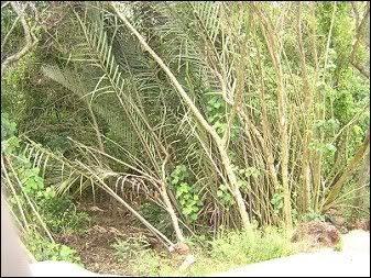
Above: Nipah palms (Nypa fruticans)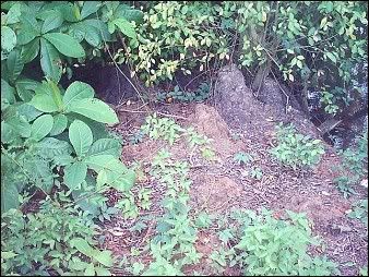
Above: Holes of mud lobsters (Thalassina anomala)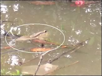
Above: Circled is Giant Mudskipper (Periophthalmus schlosseri)
Discussion:
Construction of the new Sengkang sports complex has cleared the vegetation and notably, Sungei Punggol is in close proximity with it. Also, further north after the Tampines Expressway flyover, the west side of the river bank has been cleared of mangrove probably for the Punggol 21 construction purposes. It has to be taken into consideration shall the waste water sediments runoff from these construction sites enter into the river, the mangrove and marine environment will be affected adversely and significantly. Also, monsoon drains or canals that lead to the river will further fluctuate the salinity of the river by providing more freshwater during stormy rainfall.
Above: Construction for the new Sengkang Sports Complex and Community Club has begun beside Sungei Punggol.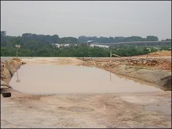
Above: If the sediments runoff to the river at the side, there will be damages done to the mangroves and the marine environment.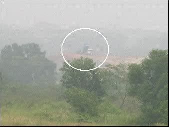
Above: Construction going on, near the northern river banks.
As Sungei Punggol is in close proximity to the new housing estates of Sengkang and Punggol, pollution in the natural habitats has worsen and many rubbish were found lying trapped since the mangrove acts as a filter. However, the pollution may affect the growth of the plants and presence of oil may affect breathing roots by depleting oxygen in the mangrove soil. Since the opening of Punggol Marina, sea sports activities have been taking place in the river and contamination may occur from these recreational boats that may affect the surrounding marine and mangrove environment negatively.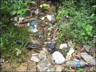
Above: Rubbish that contribute to the pollution of the mangroves of the river.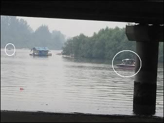
Above: Circled are the recreational sea sports spotted along Sungei Punggol. The photo is taken underneath the Tampines Expressway Flyover.
Last year, Public Utilities Board has announced that Sungei Punggol will be dammed to create an estuarine reservoir by 2009. However, this may affect the growth of the mangroves in Sungei Punggol. The reason why most mangroves are found in salinity waters is because freshwater species cannot adapt to this adverse salinity condition. If the waters of the river become fresh with no salinity after damming, there will be competition between the mangrove species and the more aggressive freshwater plant species for growth along the banks. This will in turn lead a decrease in mangrove with a possibility of being wiped out. With dams, tides and salinity from Johor Straits will no longer be a contributory factor to the survival of mangrove and the hydrological and ecological aspect of the river will be changed.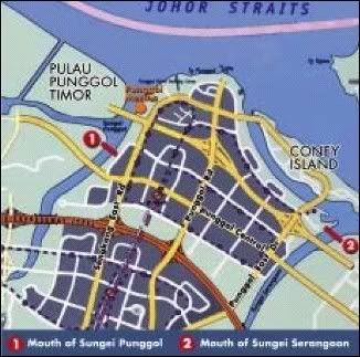
Above: (1) refers to the point of damming just before Pulau Punggol Timor for the future reservoir at Sungei Punggol.
However, we must realize that the government does recognize the need to conserve nature areas and an example will be Chek Jawa. From the Urban Redevelopment Authority’s Draft Master Plan 2003, a new 20 hectares Sengkang Riverine Park will be built and it will run along the banks of Sungei Punggol in Sengkang New Town. A 15m wide linear coastal promenade was also proposed the river with park connectors. Fortunately, the park will then incorporate the natural vegetation into the park to retain the natural character, and hopefully the river wall from the illustrated picture will not be constructed or else the mangroves will have to be deforested. From the photo of early 2005, the stated land for the riverine park was barren with vegetation. Therefore, the presence of the huge white cellulose covering is most probably to prevent soil erosion and to promote the growth of grass for the new park since sunlight can still penetrate across the layer. On site, indeed, it was observed that there were grasses growing healthily underneath it.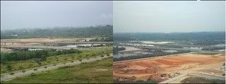
Above: The photo on the left was taken during early 2005 while the photo on the right was shot at the same place on 15 October 2005. As seen, clearing of vegetation has been done for the new sports complex and it has thinned the mangroves. At the back of the photo, what seems to be white sand is actually a layer of cellulose covering over the barren piece of land, as compared to the earlier photo.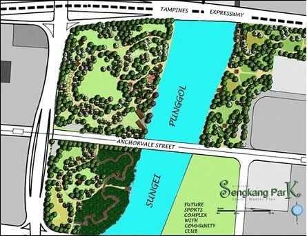
Above: The proposed Sengkang Riverine Park with the Sports Complex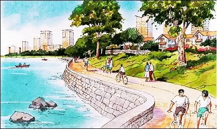
Above: The proposed coastal promenade in Punggol that may cause the loss of mangrove by the rivers of Sungei Punggol due construction of river walls.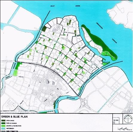
Above: The Green and Blue Plan for Punggol with Sungei Punggol featured by URA’s Master Plan 1998
During November 2002, the Subject Group proposed in their report on Parks & Waterbodies Plan & Identity Plan for the URA to look for ways to maximize access from the proposed sports stadium to the waterfront and to landscape the edges of Punggol River in order to soften the banks and make it look more natural. The response was that National Parks Board will take the landscape of the riverbanks into consideration and it will in turn be beneficial for the mangrove through conservation measures.
Conclusion:
It is heartening to see the regeneration of mangroves in Sungei Punggol for it provides a natural habitat for the diversity of fauna and flora found cohabiting in the mangroves. However, human impacts will lead to a loss in quality, originality and uniqueness of the natural character of the river life. Therefore, we need to appreciate and understand the need to conserve the remaining nature areas of Singapore from the impacts of urbanization. Given that the total extent of mangrove area left in Singapore comes to less than 1% of the total land area from an estimate 13% in 1820s, it deserves our every effort to protect and conserve it as an endangered natural habitat and ecosystem for the next generation.
References:
All diagrams are from respective sources below. Photos were self-taken.
Ho Hua Chew. (July-September 2003). Nature Areas Face Great Uncertain Future by Ho Hua Chew. Nature Watch.
L. Lu, B.P.L. Goh and L.M. Chou. (June 2002). Effects of coastal reclamation on riverine macrobenthic infauna (Sungei Punggol) in Singapore. Journal of Aquatic Ecosystem Stress and Recovery. Issue: Volume 9, Number 2. Pages: 127 – 135.
E.C. Chong and Maylene G.K. Loo (1990). A Hydrobiological survey (1988) of Sungei Punggol. Costal Living Resources of Singapore. Pages: 63-71
Ng PKL & Sivasothi N. (Editors). (1999). A guide to the mangroves of Singapore 1. Singapore Science Centre.
Ng PKL & Sivasothi N. (Editors). (1999). A guide to the mangroves of Singapore 2. Singapore Science Centre.
Jose Raymond (2-3 October 2004).Two more dams in the pipeline. Weekend Today. Page 2. (Newspaper article)
Lu Xi Xi, Wong Poh Poh and Chou Loke Ming. (2005). Singapore's Biophysical Environment.
http://www.ura.gov.sg/pwbid/
URA and NParks Response to Parks and Waterbodies Plan and Rustic Coast proposals. Accessed on 22 October 2005
http://www.ura.gov.sg/dgp_reports/punggol/main.html
URA- Punggol Planning Report 1998. Accessed on 22 October 2005
http://www.dbs.nus.edu.sg/lab/reef/SasiNayar.htm accessed on 23 October 2005
http://mangrove.nus.edu.sg/ accessed on 23 October 2005
http://www.fishesnpets.net/explore/ accessed on 26 October 2005
Friday, May 11, 2007
Impacts on mangrove at Sungei Punggol
Subscribe to:
Post Comments (Atom)


2 comments:
Wow! That's an awesome study.
Thanks for sharing it!
you're welcome Ria :)
Post a Comment